Location, Location, Location
What are the three most important things for real estate value? Location, location, location. This time-worn adage applies just as well to builders and contractors. What with setbacks, easements, drainage planning, and other code compliance issues, it’s important to get the location for a structure properly on the lot. There are plenty of ways to accomplish this but implementing the capabilities of SketchUp can streamline the process with a very respectable level of accuracy.
Homework
It’s unusual to get a homework assignment before taking a class but its necessary in this case. Since most plat drawing line angles are given in degrees:minutes:seconds format and SketchUp (free version 8 at least) doesn’t have that capability. It requires importing a “Ruby Script” to add the function. Even using a construction calculator to enter d:m:s angles and converting them to decimal angles doesn’t help since SUv8 only allows three decimal places. I think it would take at least four spaces right of the decimal and probably five to be accurate enough. So the homework assignment is in SketchUp go Help>Learn About Ruby Plugins. Once you understand the process download this plugin: Survey Tool. After installing it you can find it under the >Tools>Survey Tool tab. As you watch the video you’ll see how I access the Plugin and use it to create a plot plan layout from an acutal plat drawing I got from the local county courthouse.
Plat Drawing
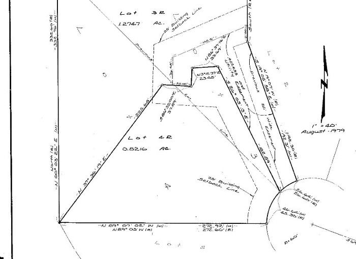
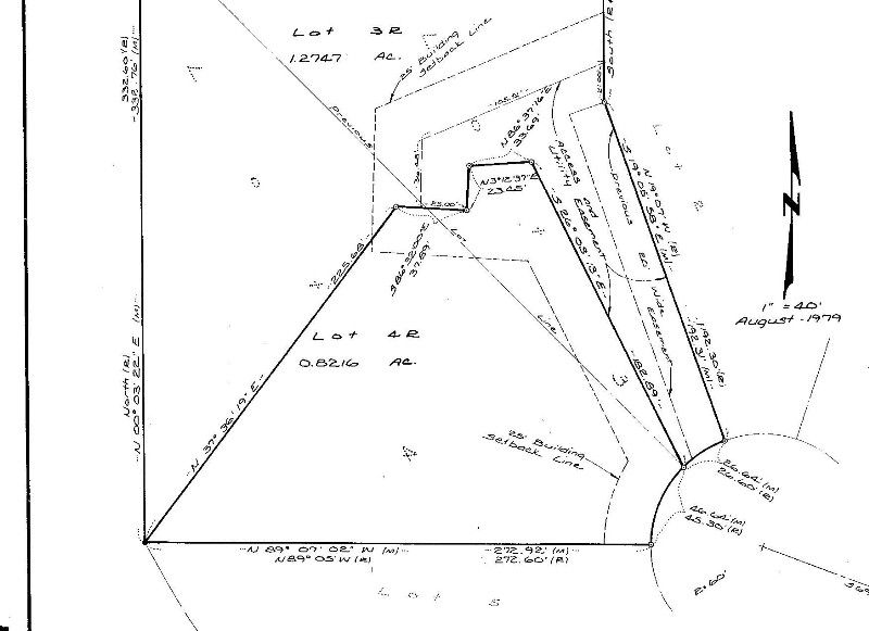
I chose a random cul-de-sac plat for this tutorial to show the real “strength” of this process which is the ability to handle abstract angles and even a radius. While everything I show here applies to simple rectangular lots, I don’t want to be accused of being a lightweight 🙂
Do It To It
With the plat to follow and a PlugIn to work with I get about the business of creating the plot plan in SketchUP
Plat Placement
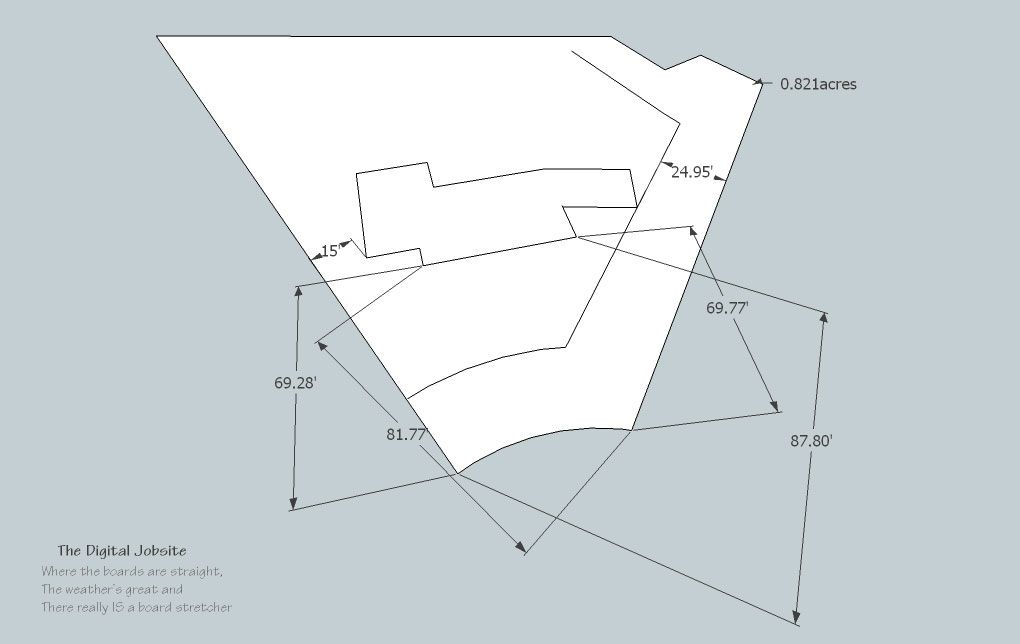
In this video I create a random house footprint and place it on the plat. This is where the benefits of this process really kick in because it is virtually effortless to explore endless location options. Rotating the footprint, shifting it to any orientation, maximizing front, back or side yard sizes and distances and all manner of possiblities can be explored while SketchUp grinds out any dimensions you want to derive.
Extra Curricular Work
After creating the plot plan for this tutorial I was a little annoyed by the fact that the area calculation for the lot is shown in square feet while the plat drawing shows 0.8216 acres (select the lot area and go right click>Entity Info>Area). It feels hypocritical to proclaim the benefits of SU only to have to resort to a construction calculator to do a square foot to acres conversion, so I queried the SU Help Center and found this little Ruby Script to do the conversion for me. I learned that if you select the area then go Window>Ruby Console and paste this script into the box, it produces a text tag linked to the center of the selected area and shows it in acres. So if you download the Plot Plan model created for this tutorial from the SketchUp Component Warehouse you now know how I got the area to show in acres, not square feet.
Disclaimer
I am NOT a registered/certified surveyor, not even an un-registered one, just a guy who’s been around this stuff awhile like many of you. Taking this into consideration, apply any results you derive from this process using your own sensibilities. When in doubt, consult a professional, you’ll both be glad you did.
Also, the calculations in this example are assuming a flat piece of real estate and DO NOT account for inevitable discrepancies that would be encountered on a sloped lot: the greater the slope, the greater the discrepancies. These factors could be incorporated into the process but that would be a topic for a more in-depth tutorial.
There You Have It
Hope this tutorial has given you at least a little food for thought for using SketchUp to expand your capabilities in doing plot planning for your own work or interest.
Thanks for watching and please take a second to Thumbs Up/Down or post a comment as you navigate away…
Fine Homebuilding Recommended Products
Fine Homebuilding receives a commission for items purchased through links on this site, including Amazon Associates and other affiliate advertising programs.

The New Carbon Architecture: Building to Cool the Climate

A House Needs to Breathe...Or Does It?: An Introduction to Building Science

Musings of an Energy Nerd: Toward an Energy-Efficient Home








View Comments
I've enjoyed all of these tutorials and found them very helpful! I've picked up several shortcuts that I didn't know existed just by watching.
How about for your next tutorial to do this with a sloped lot? That would be very informative.
TomLev,
There is a whole aspect of SketchUp that I know next to nothing about: Sandbox Tools. The little I do know leads me to believe that they would be the ticket for modeling a sloped/contoured lot in detail and then placing a structure on it. I'm sure it would take a fair amount of on site surveying to gather the necessary data to complete an accurate model though.
Without going to that extent, if a lot was fairly flat but sloped, elevation data from the corners and a few key transition points could be modeled into a few basic sloped planes. A foundation outline could then be placed onto the basic contour and measured in similar manner to the flat-lot example.
I'll conduct an informal poll on your request for a tutorial to show the process on a sloped lot (in the less-extensive method) and post it if a few more "yes" votes are cast.
Glad you've enjoyed the tutorials... stop by The Digital Jobsite anytime you get the chance.
Thanks,
Matt AKA The Timber Tailor
How conveniently timely!
I down loaded "schetch up" on my Mac, but I have problem to down loading the "The survey tool". To complete this process. What is it I'm doing wrong.
ARV109:
I'm a PC guy so wouldn't be any help if the download fail is a MAC issue. Have you downloaded any other PlugIns into SketchUp and just the Survey Tool doesn't work or won't any plugins work?
I would suggest that you try to download another plugin like the Volume one in the Mud Math post on the Digital Jobsite and see if that works.
If neither do its probably that you need to learn how to get Ruby Script Plugins to work in general. If it is just the Survey Tool that doesn't work you should be able to find help in SketchUp Plugin forums online because other MAC users will most likely have encountered any incompatibility issues.
Good luck... and check back for more at The Digital Jobsite when you have time..
I am wondering if there is an update to this. I cannot get the plugin to work in SU 2014, and I cannot seem to find anything on the web recently that will enable me to do this. The tutorial is exactly what I want to do as I have an irregular shaped lot with 4 curved lines. I have the plat map with the bearing and distance, but cannot get this to work.
Any advice?
Hi user-3710855,
I'm not aware of an update for the plugin used for this tutorial. I haven't had need to do any of this type work for some time so didn't know it's apparently no longer working.
I would be surprised, however, if there isn't something out there for this useful function. There are so many plugins out there with more being created constantly it seems there should be something available.
You could contact Matt Donley of MasterSketchup.com who I find to be very knowledgeable and well-connected with everything SketchUp related. If he doesn't know I'm sure he'll know someone who does. For what it's worth you can tell him I sent you...
Regards,
Matt Jackson