I seem to remember a small article about a contractor who used a gps to layout a complicated foundation.If anyone has any info on the article or product or similar product please post info. It may have been in the “other” magazine.Thanks in Advance
Discussion Forum
Discussion Forum
Up Next
Video Shorts
Featured Story
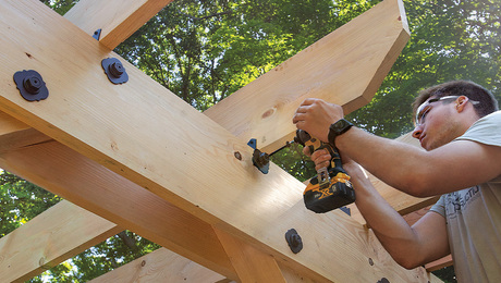
Built from locally sawn hemlock, this functional outdoor feature uses structural screws and metal connectors for fast, sturdy construction.
Featured Video

Highlights


"I have learned so much thanks to the searchable articles on the FHB website. I can confidently say that I expect to be a life-long subscriber." - M.K.
Fine Homebuilding Magazine


Fine Home Building
Follow
-
Fine Homebuilding
Dig into cutting-edge approaches and decades of proven solutions with total access to our experts and tradespeople.
Start Free Trial Now -
GBA Prime
Get instant access to the latest developments in green building, research, and reports from the field.
Start Free Trial Now
- Home Group
- Antique Trader
- Arts & Crafts Homes
- Bank Note Reporter
- Cabin Life
- Cuisine at Home
- Fine Gardening
- Fine Woodworking
- Green Building Advisor
- Garden Gate
- Horticulture
- Keep Craft Alive
- Log Home Living
- Military Trader/Vehicles
- Numismatic News
- Numismaster
- Old Cars Weekly
- Old House Journal
- Period Homes
- Popular Woodworking
- Script
- ShopNotes
- Sports Collectors Digest
- Threads
- Timber Home Living
- Traditional Building
- Woodsmith
- World Coin News
- Writer's Digest


Replies
From what little I know after a six hour introductory course to GPS, it is not fast enough, accurate enough, or inexpensive enough to do a footing with.
basicly, The more expensive the unit is, the more accurate it is, and the longer you leave it in place, the more accurate it is. It constantly seeks, triangulates, and rectifys readings.
An accurate surveyors system will set you back about as much as a Lexus.
Get a laser level
Excellence is its own reward!
This job is a 20,000 sq ft house on a 100ft sq ft print , built completly of poured columns, beams and elevated slabs. The investment would be minimal.
This job is a 20,000 sq ft house on a 100ft sq ft print , built completly of poured columns, beams and elevated slabs. The investment would be minimal.
Rent a transit..........if you can't do it with a transit, you should find another career.
Gabe
Thanks for the advice.I wanted a system to tell me where each point would be the in three dimensions from any other point. I have found the article and the product. http://www.trimble.com/ls9203d.html
Here are the specs.
Thanks. I could use one like that occasionally.
But it is not any kind of GPS system, it is a laser system.
Distance is measured by recording time it takes to reflext back to source. Angles are clicked in and a chip of some kind figures your locations for you. It would work in an underground bunker where it never saw a satellite..
Excellence is its own reward!
Thank you for your reply. I had thought I read about it in a small article, apparenttly I did not correctly remember all of the details.
>>An accurate surveyors system will set you back about as much as a Lexus.
If I could only afford to have one of them, I would rather do my survey with a RX330 than the GPS surveyors system. Hey, do you think the IRS will let me write off the Lexus as a surveyor system?
Tom
sure, you've got to have something to haul the chains and transit around in!
I'll bet George Washington wrote off his horse.
Excellence is its own reward!
After reading the other posts I think I might have a solution for you.
Take the plans to any competant liscensed land surveyor, and have him calculate coordinates on all of the required points. These can just be horizontal, or you can have him do the vertical control also.
Having these will allow you to set any point from any other point in the foundation layout. You just have to have a transit/theatolite and be able to turn angles to do this.
I'd suggest that you set a couple of points first, and use those for the construction of the remainder. He can calc all of the ties from these points.
You might want to ask for an estimate for them to do the whole thing.
They can set offset stakes with cuts/fills for everything.