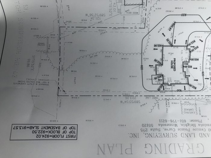
How is the elevation 9xx.xx determined?
Also im assuming this unit of measurement is expressed in ft?
How is the elevation 9xx.xx determined?
Also im assuming this unit of measurement is expressed in ft?
Hover's smartphone app offers an easier way to get precise 3D scans.
Dig into cutting-edge approaches and decades of proven solutions with total access to our experts and tradespeople.
Start Free Trial NowGet instant access to the latest developments in green building, research, and reports from the field.
Start Free Trial Now


Replies
The drawing is upside down and small scale, making it difficult to read. However, it mentions Mendota Heights, MN. Wikipedia lists the elevation of Mendota Heights as 912 ft. so it's a reasonable assumption the the 9xx.xx is elevation above sea level. The drawing may cite some elevation reference point.
The drawing mentions "...AND LAND SURVEYING, ...Centre Point Curve, Phone 651-776-6211" Googling those fragments leads to Lake and Land Surveying in St. Paul, MN, so a call to that number would probably be productive.
The drawing seems to show a first floor elevation of 924.02 ft, a foundation top at 922.50 ft, surrounded by a grade line at 920 ft, implying a 2.5 ft. drop to provide drainage away from the foundation. That theory is reinforced by arrows pointing away from the footprint of the proposed house, towards the 920 ft. elevation line.
A 2.0 ft drop; not 2.5 ft since there is a ground level set at 922.00 ft around the proposed house. Good luck!